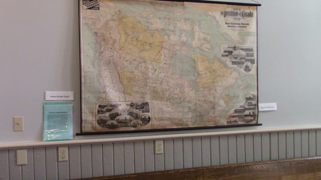
One of the prized possessions of the Red Brick School (RBS) is an original map of the Dominion of Canada of 1903. The map was issued by the direction of the Hon. Clifford Sifton, Minister of the Interior, and is dated 1903, copies of which may have hung in all elementary schools of the era. This however, was not the original purpose of the 1903 map.
Hanging in the Junior classroom, the 1903 map is the single most visited/commented upon artifact at the RBS, with its reminder of the huge political and cultural changes which have taken place in Canada since 1900. However, the pristine condition of the map today does not tell the whole story.
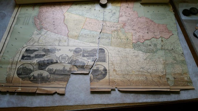
This map, badly in need of loving care, was donated in 2016 by Jean Baker Phifer. Although, by 2016, the junior room in the restored RBS, furnished as an Edwardian era, 1900-1910, classroom did contain a Canadian map, it was c1950 (complete with a Neilson candy bar advertisement). Hence, this gift showcasing Canada in 1903 was of great interest to EAHS.
After considerable searches for a qualified conservationist and discussions with Basis Baklinski, Peterborough, she was hired by the EAHS to undertake the restoration of this age appropriate map.
One of her early emails included the following ‘Your map is exciting and beautiful and absolutely restorable. I did a bit of on line research last night to see if I could find an image of the same map…. I was unable to find an exact replica but I did find one map with the same logo in the top right corner but a slightly different photo just below it which leads me to think that perhaps your map may be quite unique.’
The original purpose of this map was part of a campaign by the Wilfred Laurier government to attract settlers to the Canadian prairies. Minister of the Interior, Clifford Sifton, responsible for immigration, 1896-1905, knew that in order for Canada to thrive, it needed immigrants.
Immigration to English-speaking Canada had traditionally meant attracting people from Britain or the U.S. But by the mid-1890s not enough people from these locations were coming to fill the vast prairies. Clifford Sifton expanded his list of preferred immigrants to include eastern Europeans with an agricultural background.
To that end he launched an aggressive advertising campaign, offering 160 acres of FREE LAND, in which the most effective tool was the immigration pamphlet (the where and how of coming to Canada), translated into dozens of languages. Translated into dozens of languages, they were distributed throughout Europe. (See the Article: Free Land).
The original 1903 map formed part of this advertising campaign, with a large version later reproduced by Dodd & Mead Co. (the EAHS map).
Provenance of the 1903 map
- it was a gift from Jean Baker Phifer whose mother and grandmother had both taught at the same rural school: Thorpe PS, Lennox and Addington
- at Thorpe the map became a teaching prop (likely eventually forgotten in a cupboard) until the 1960s when the closing of the school (and probably the non interest of the new consolidated school) made the existence of the map problematic
- with the demise of the school the last teacher, Jean’s mother, Ann Baker, brought the map home with her
- but how/why had this 1903 map, intended for usage by federal government land agents, arrived at a small rural school
- Jean drew upon her family history to formulate the following theory: a future brother-in-law of Jean’s grandmother worked in Ottawa for the federal government in the early 1900s, it was most likely he who acquired this unusual map of Canada for Florence Baker’s use in her classroom (rural schools were notoriously short of funds), when the school closed in the 1960s the map was reclaimed by the Baker family
- by 2016 the map had been transported to Ottawa, where it was languished in a basement for 50 years, miraculously escaping removal to the Ottawa dump